Tibetan Plateau's 'Flowing' Crust Challenges Tectonic Theory, Reveals Earthquake Risk
N
News18•02-02-2026, 15:07
Tibetan Plateau's 'Flowing' Crust Challenges Tectonic Theory, Reveals Earthquake Risk
- •New satellite research reveals the Tibetan Plateau's crust behaves like a slowly flowing liquid, not rigid rock, challenging traditional tectonic theories.
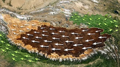
- •The eastern part of Tibet is moving eastward at 25 mm/year, while other areas move at 10 mm/year, indicating internal stretching and pressing.
- •The Kunlun Fault is weaker than expected, allowing the plateau's interior to flow eastward and release energy from the Indian-Eurasian plate collision.
- •Vertical land displacements (5 mm sinking/rising) suggest potential future earthquake zones across the 2.5 million sq km plateau.
- •An unprecedented dataset of 44,000 radar images and 14,000 GNSS measurements enabled millimeter-precision mapping, crucial for improving earthquake risk models.
Why It Matters: The Tibetan Plateau's unexpected 'flowing' crust redefines tectonic understanding and highlights new earthquake risks.
✦
More like this
Loading more articles...